


Memory-Map

Descrição do Memory-Map
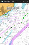
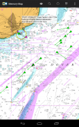
O aplicativo Memory-Map transforma seu celular ou tablet em um Plotter GPS ou marítimo com todos os recursos e permite que você navegue com mapas USGS Topo, gráficos NOAA Marine e outros mapas especializados, mesmo sem um sinal de internet sem fio.
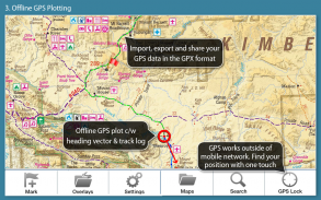
Os mapas são baixados on-the-fly e podem ser pré-carregados para que possam ser usados offline. Depois que o aplicativo e os mapas forem carregados no telefone ou no tablet, a cobertura da rede celular ou a conexão com a Internet não serão necessárias para navegação GPS em tempo real.
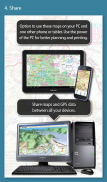
O aplicativo Memory-Map pode ser usado como um navegador GPS independente, mas também pode ser usado em conjunto com o Windows PC ou Mac (download gratuito) para planejar, imprimir e carregar mapas, waypoints e rotas para o telefone / tablet .
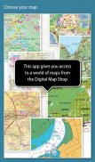
O Memory-Map inclui acesso gratuito a mapas topográficos de escala de 1: 250.000 e muitos outros mapas gratuitos em todo o mundo. Mapas mais detalhados estão disponíveis para download e compra com uma opção gratuita de demonstração com limite de tempo. Os mapas disponíveis incluem Levantamento de Ordens, Hema, quadras USGS, NOAA, Almirantado Britânico e DeLorme. Os mapas podem ser usados no seu PC, bem como no seu telefone e tablet. O recurso Cloud Sync permite que você mantenha os dados de sobreposição consistentes em todos os seus dispositivos.
Características incluem:
Acesse uma vasta gama de mapas e gráficos mundiais.
Transfere automaticamente um mapa gratuito da sua localização atual
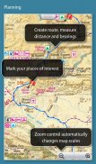
Crie e edite marcas e rotas.
Importar e exportar marcas, rotas e faixas no formato GPX aberto
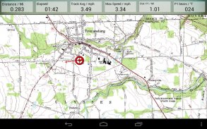
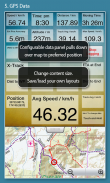
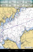
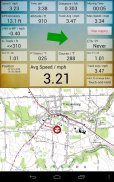
Exibição; Posição, Curso, Velocidade, Posição, Altitude e médias
As coordenadas de posição incluem Lat / Long, UTM e GB Grid
Unidades exibidas em Estatuto, Náutico ou Métrico
Suporte para sensores GPS e Bússola, quando disponíveis.
Índice de Placename, pode ser usado offline.
Mover o mapa, bloquear a posição GPS e rolar automaticamente o mapa
Registra trilha / rastreio breadcrumb.
Compartilhar marcas de posição ou tracklogs como arquivos GPX
Alarme de proximidade
Recursos completos de instrumentação marítima, com alarme AIS, DSC e Anchor
Interface de dados NMEA via WiFi ou Bluetooth
Alarme de colisão AIS, com limites ajustáveis para as metas de Classe A e Classe B
Exibir notificações de alarme e dados de navegação no relógio Android Wear
Barômetro e altitude relativa
Memory-Map - Versão 2.9.0
(03-02-2021)
Memory-Map - Informações do APK
Versão do APK: 2.9.0Pacote: com.memorymap.mm2Última versão de Memory-Map
Outras versões


Apps na mesma categoria

Você também poderá gostar...


